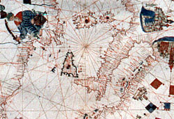
 64. Nautical map by Banet Panadès
Like that of Giulio Petrucci, this parchment also probably comes from the Cospi collection.
The map charts the whole of the Mediterranean basin, including the Black Sea with the Crimea Peninsula and the Sea of Azov, and a part of the Atlantic Ocean facing Europe and Africa.
It has the same features as the map of Giulio Petrucci while the inscription reads:
Banet panades mallorqui in pallermo añy 1556
On the neck of the parchment there are three religious figures, the middle one of which is the Madonna kneeling with the Baby in her arms.
P. Frabetti (1959).
P. Frabetti (1978), p. 81.